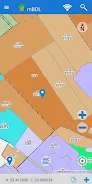
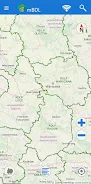
Introducing the mBDL app - your mobile forest data bank! This application provides direct access to forest maps on your phone or tablet. It offers a variety of forest thematic BDL maps, including basic maps, tree stands, ownership forms, forest habitats, plant communities, hunting maps, tourist development maps, fire hazard maps, and more. You can also display raster backgrounds like topographic or aerial/satellite orthophoto maps.
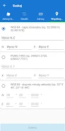
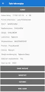
The mBDL app allows you to download data for offline use, making it convenient to use in forest districts and national parks even without an internet connection. In addition to maps, you can access a full taxation description for forests of all ownership forms, with detailed information on species of trees and shrubs, forest addresses, economic indicators, and more.
The app also offers functionalities like area and distance measurement, GPS recording, route recording, and navigation. You can export saved waypoints and routes as KML files and easily share them with others. Searching for forest divisions based on forest addresses, cadastral parcels, or coordinates is also possible.
Get acquainted with the app's basic functionalities through the provided manual. Download the mBDL app now on https://www.bdl.lasy.gov.pl/portal/deklaracja-mBDL
Features of this App:
- Direct access to forest maps on phones and tablets.
- Forest thematic BDL maps, including basic map, tree stand, ownership forms, forest habitats, plant communities, hunting map, tourist development map, and fire hazard map.
- Option to display predefined raster backgrounds such as topographic map or aerial/satellite orthophotomap, as well as maps from external WMS services.
- Offline functionality allowing the use of maps for forest districts and national parks even without an internet connection.
- Online access to a full taxation description for forests of all ownership forms, including species of trees and shrubs, detailed description, forest address, economic indications, and more.
- Additional functionalities for area and distance measurement, GPS location recording, route recording, and simple navigation to a given point.
Conclusion:
The mBDL App provides convenient and comprehensive access to forest maps and information. With various thematic BDL maps and the option to display additional raster backgrounds and WMS services, users have a range of map choices. The offline functionality allows for continued use even without an internet connection, making it useful in remote forest areas. Moreover, the App offers detailed taxation descriptions for forests, making it an informative tool for forest owners and enthusiasts. The additional functionalities for measurement, GPS recording, and navigation further enhance the usability of the App. Download the mBDL App now to explore and navigate forests with ease.